


The complete planner and guide for travel and leisure on the River Thames including where you can go, how you get there and what’s on the way - includes these key features:
Thames Map and Guide:
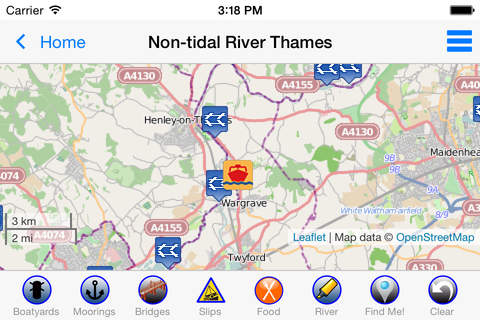
•Interactive River Map: self-contained - no internet connection needed
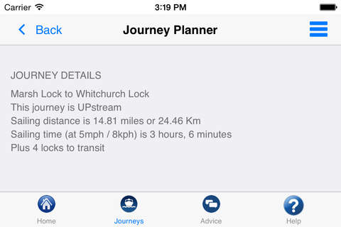
•Journey Planner: time and distance between any two of 74 river points
•Locks: need to know detail on every lock
•Bridges: headway in metres and feet
Map extras:
Show any combination of pubs, restaurants, hotels, marinas, slipways, boat hire, boat maintenance, stores and more
Should I sail?
•Weather for selected locations
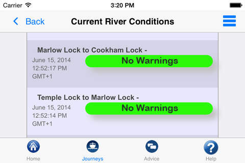
•Current river conditions
Boating Advice:
•Rules for the River
•Preventing Problems
•Emergency Help and Guidance (RNLI approved)
INTERACTIVE RIVER MAP: pinch or squeeze to zoom to the required level of detail. Add any combination of locks, moorings, boatyards, marinas, pubs, restaurants, lodgings and/or bridges; tapping any icon pops up further details including phone number (where appropriate). The interactive map is built-in to the App so you do not need an Internet connection to see where you are and facilities near you (PLEASE NOTE: this means a large download - please be patient, it’s worth it!).
JOURNEY PLANNER: select a starting point and destination from the supplied list of 70+ landmarks (including locks, marinas, moorings and places of interest) and immediately see the sailing distance, direction (up or downstream), sailing time (at 5 mph) and the number of locks to transit to complete your journey.
LOCK FEATURES: every Thames lock is listed in order from Cricklade Bridge to Teddington with distance to next lock both up & downstream. Touch any lock to see much more information including: telephone number; post code; lock type; width, drop & length; lock keeper’s hours; facilities available (such as WC, water, pump out etc). From the lock detail just tap to put this lock in the middle of the interactive map.
BRIDGE HEADWAY: every bridge listed in order with headway in feet and metres; bridge headways are colour coded for ease of use & instant check to see if you need to lower any masts.
All the above features are built-in so are available even without an Internet connection.
WEATHER: select one of 14 location on the river for an up-to-date weather forecast for today and tomorrow (includes temperature, winds, humidity, visibility, sunrise and sunset).
CURRENT RIVER CONDITIONS: for safer river use always verify the current official conditions before setting off; these are provided by the Environment Agency (the River Thames authority) and categorised as Red, Yellow or Green – tap to view an explanation of the colours.
IN CASE OF EMERGENCY: River Thames includes an SOS section with information, endorsed by the RNLI, on how to deal with various problems including: Man Overboard; Boat Sinking; Boat on Fire; Boat Drifting. NOTE: these sections should be studied before embarking so that you can react properly to any emergency. Better still: take an appropriate course before using the river.
HELP: tips on using River Thames Guide to help plan your journey, find somewhere to eat or stay, using the map, and more.